September 8, 2010

WTF.

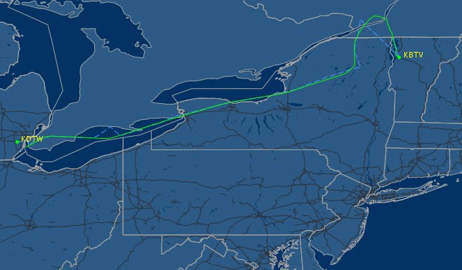
These two planes crossed paths. One of them deviated northbound and the other southbound west of Burlington. I still don't get it. They seemed to fly through the worst of what was depicted on radar only to bail out and fly around the eastern edge of the storms....


It was nice and sunny, with a smooth ride, in the chair from which I was observing.

Oh, and the Traffic Management Unit insisted the weather wasn't affecting our sector. Nope, not at all.


Till next time,

DM

PS. And as always, thanks for www.flightaware.com for allowing us to relive the glory that was a Tuesday evening.

September 3, 2010

Out of Range

Last weekend was pretty good, overall. It was hot out, and a little humid, as I rolled into work on Tuesday (aka, Monday for me). I left the sunshine and my body prepared for the shock of the cold, dark control floor. It always seems colder inside when its hot outside. I make a mental note to grab my hoodie on my next break (yes, I made sure to bring it with me even though it was 96 outside).

The next shock to my system was the chaos that immediately ensued at the UCA/ART sector, my first session of the work-week.

The sector was busy with normal westbound traffic climbing towards Syracuse VOR. I had a big spacing requirement to IAD (40 Miles-in-trail), and lo and behold, I have a few of them coming from different directions with different headwinds.

The military is out in force today. They had taken some time off, as far as our airspace is concerned, and there are new flights that I've never seen before out of Maryland. They are using a small block of airspace called "Range 1", but only from 23000' and below, so it's not a big deal. Depending on the mission, the military uses different areas of airspace so they can fly training missions safely separated from IFR traffic and off our frequency. The schedule calls for another training flight to show up from BAF in Massachusetts soon, and they are requesting "Viper All", which encompasses a huge portion of my airspace, as well as a small part of Montpelier Sector. They generally request 8000' to 50000', with some western parts of that all the way down to the ground. When that happens, I need to get EVERYONE else out of there before the fighter jets can be cleared in so they can accomplish their training in sterile airspace.

The traffic along J547 is pretty steady, but increasing by the minute. I am getting alot of traffic from Canada going to IAD, and I need to figure out my sequence. As a big gaggle of planes at various altitudes enters my airspace from the east, I see the MURDER2 flight (all military callsigns will be altered slightly to protect the innocent) from BAF coming to request Viper All airspace. They can't have it until the Range 1 block is empty since the airspace overlaps and the training mission involved there is not associated with them. The MURDER2 flight is in a block altitude from Fl220 to FL240. An Albany departure comes off assigned an altitude just below them. It's a Southwest climbing fast to FL210, looking for Fl380. I take both handoffs begrudgingly.

The westbound flow includes a lot of traffic at FL300 today. All the IAD traffic going south needs to be at FL300 or below. This is going to be a problem. The Ottawa to Dulles flight is handed off to us from Montreal Centre, climbing to FL280 only. I think he'll stay there for a while, he wants FL320. The MURDER2 flight checks in requesting the VIPER ALL airspace. "Unable at this time, RANGE 1 is still active for a few more minutes" "Roger".

Normally, when our military flights show up to use our airspace, they file a full flight plan to and from the set of airspace, or blocks, that they want, incorporating a delay message in their flight plan so we can just clear them on their way when they are done "as previously cleared". These new guys using the Range 1 didn't do that.

"HORSE3 flight requesting IFR clearance." A few planes were checking in on other frequencies, but that caught my ear. It takes a few moments to realize that this HORSE flight is coming out of the RANGE 1 block and wants an IFR clearance to Maryland. However, they are in Wheeler Sack Approach's airspace. We call them and get control, and I clear HORSE3 on the preferred route and allow them to climb to 16000. I ask them if the Range 1 is cold/inactive now that they are done, they reply with a "we're not sure, I think there are more planes in there." My D-side is typing fast and furious getting the HORSE3 flightplan in the computer. I take a quick scan of the rest of my traffic and come up with a plan. The first Dulles is actually from the northeast, so I'll leave him at FL320 (I tell RKA what to expect and give them control reference my traffic) and go over the top of my westbound traffic. The second one gets slowed down, but I climb him to FL300. I take a YYZ arrival that is crossing with the second IAD guy and take him down from FL300 to FL280. I turn another guy at FL300 20 degrees right (missing the IAD guys and getting him out of the way of the ALB departure) and turn the Albany departure a little left and push him up above everyone. A shortcut and higher, bonus! I switch a plane or two to Cleveland Center and I get interrupted by MURDER2 reminding me that they are about to enter the Viper All airspace. The first Dulles is stll in the airspace MURDER2 is requesting, along with a pointout from Sector 53 going to Seattle and a Saranac Lake arrival at 17000 descending. I tell the MURDER2 to enter the VIPER ALL airspace but stay in their limited block altitude for now.

My D-side is calling the sectors around us to turn planes away from the Viper All so we can use it soon. The necessary coordination requires about 8 phone calls. The HORSE3 flight is clear of my Saranac arrival and so I issue a climb to the requested FL200 and I flash the handoff to the next sector. A canadian aircraft that is clearly from Quebec tries calling me for VFR advisories. "Unable VFR at this time" I respond. Yet, another VFR calls me....

BIRCH5 calls requesting a pop-up IFR clearance as well, this time to BAF to the southeast. "Did you file an IFR flight plan" "Affirmative" "Roger, maintain VFR while I pull up your flight plan". My D-side and I are frantically searching the computer for the flight plan, but find nothing. I switch a few planes while my D-side looking into the situation.

HORSE3 calls. "We're encountering IMC conditions, we need to split up and become two flights."

"Roger, are you with HORSE4, same flight plan?"

"Affirm"

HORSE3/4 is about 12 miles north of SYR, which, at FL200, is where 3 Centers meet. The coordination on this could get hairy. I get DNY sector to flash the handoff back to me (luckily New York Center hadn't taken the handoff from them yet), and in a split second I decide to turn the HORSE flight to a 330 heading, keeping them in my airspace. I pull up a code for the new HORSE4 flight plan and have that plane come up on my frequency when he's ready.

Sector 39 calls for a few handoffs on the other side of my scope and I, again, begrudgingly say "radar contact," followed by a few clicks on the datablocks to take the handoff. MURDER2 is entering the Viper all now, and he reminds me of it, again. Yah, yah. I'm working on it.

"MURDER2, standby. Is BIRCH flight still on frequency?"

"Affirm, center, VFR at 9500 requesting IFR to BAF."

"Are you clear of the Range1 and if so, is it cold?"

"BIRCH is clear, we're the last ones out, the Range is cold"

"Roger, standby for IFR."

"MURDER2 can you take the Viper All from 11000 up to FL290 for now(?), I have traffic still in there for a few minutes."

"We'll take whatever you can give us..."

"Roger, MURDER2 is cleared into the Viper All airspace 11000 up to FL290, Wheeler Sack altimeter 30.02, frequency change approved, monitor Guard for the rest of the block in 10 minutes."

"Roger, switching MURDER2."

"HORSE3 what is HORSE4's requested altitude?"

"We'll both take FL200, but we, HORSE3, will take a vector to follow in-trail if that works for you."

"Roger, HORSE3, have HORSE4 come up on my frequency heading 090, HORSE3 fly heading 360."

I see the HORSE4 pop up, I issue the clearance and HORSE4 turns back to SYR to fly the preferred route to Maryland. Once I get about 8 miles, I turn HORSE3 back to SYR and he resumes the route as before.

Now, about this BIRCH flight. My D-side is finishing up the flight plan for the HORSE4, changing HORSE3 to a flight of 1....Dude, where is the flight plan for BIRCH!? I turn one of my IAD guys eastbound for spacing. I expedite another Albany departure above him, and tell a few planes that shortcuts aren't available and the rides are probably bumpy. Cleveland gives me a BTV arrival going direct (straight through the Viper), so I call them quickly to get control to turn him around the Viper airspace to the south. I'll somehow have to get that guy down to FL190 through all my westbound traffic climbing. I turn my Dulles back on course and assign a speed.

Five minutes later, everyone is clear of the Viper airspace. I got the Saranac Lake guy down and handed him off to Sector 52, the Dulles guys are all clear and on their way, mostly spaced, and any other stragglers have moved on. I tell the BIRCH to contact Albany approach and request IFR with them, since they aren't in my airspace anymore. I call MURDER2 and clear them into the whole block as they requested, thanking them for their patience.

Our usable airspace has gone from a big rounded square to more of an L shape, but I have all the same planes, and they all have to climb and descend. I feel squeezed when Viper All is active.

Lets take a look at my lame excuses for a visual aid:

The ART/UCA sector is in the middle, within the bold black lines. Other sectors are shown as thin black lines. Green lines are flights that are en-route and mostly in level flight. Blue lines are climbing aircraft, and red lines are descending aircraft.

The first pic is how the sector started off, with just Range 1, in red, 23000' and below. This is mostly a normal flow for this sector. While there are always flows that climb and descend head on with each other, we have plenty of room to turn guys out a little to keep them laterally separated.


------

The second pic shows the Viper All in red, taking up my entire northeastern quadrant of airspace. I am left with but a sliver of an L, and all the climbing and descending and level aircraft are compressed within that L, in conflict with each other. There is little, if not no, room for error. Ottawa departures are head on with Ottawa and Montreal Arrivals, Burlington Arrivals are head on with Burlington and Montreal Departures. And brace for impact if there is ever a RUT or GFL arrival in there or something. They usually come from Cleveland Center at FL410 and need to go down to 11000. Yeah....


As I take a break, all I can do is vow to do better next time. And I need to remember to bring my whole brain to work next Monday, I mean Tuesday....

Till next time...

DM
July 25, 2010

Get 'um down!


Altitude is the most basic form of separation in the 3D world of Air Traffic. It doesn't require radar, and is often the most efficient way to keep two airplanes from colliding. However, aircraft eventually run low on gas and want to land. How do we safely allow planes to descend through the maze of other traffic and what considerations are necessary to accomplish this? It's funny you should ask...

Compression

The wind is in effect 24/7. In general, aircraft with a headwind climb, descend and turn faster relative to the ground, because they are moving over the ground slower than the aircraft with a tailwind, who fly faster, but climb, descend and turn relatively slower.

In the en-route world, the winds vary greatly at altitude, and this causes aircraft with a higher tailwind component to fly faster, when assigned the same speed, as aircraft with less of a tailwind. Wind tends to be stronger at higher altitudes. Thus, as aircraft descend into the airport, the first airplane will be at a lower altitude first, with less of a tailwind then the aircraft following it down from behind. Even though they will be at the same altitude at the same point in space, the trailing aircraft are higher relative to the current time. So, if you have 2 identical aircraft at FL270, 6 miles in trail, and both are assigned 300 knots, the first aircraft will start down 6 miles (or about 1 minute)before the second one wants to. The first plane will already be one or two thousand feet lower than the back one until a minute after the first one levels at the lower assigned altitude. However, the first aircraft will gradually lose part of the tailwind sooner than the back aircraft, causing the front plane to slow down relative to the ground and the plane following. This is called compression. We need 5 miles, and your 1 mile buffer you had at FL270 will cease to exist by the time they're both down to FL180.

The vast majority of descending aircraft in my area flow eastbound, so they almost always have this tailwind compression issue. The compression for westbound traffic and headwinds is less of an issue (there would still be some compression due to the thinner air aloft), but I don't have any extensive experience with lines of aircraft doing this. This is my blog, so we'll stick with what I'm familiar with.

There are a few techniques controllers use to prevent this from happening. The first solution is the assign the back aircraft a speed at least 20 knots slower than the front aircraft. The first plane would be assigned 310 knots or greater, the second 290 knots, the third 270 knots, and the fourth would be assigned 250 knots. As they reached their lower assigned altitude they would then be reassigned 310 knots to keep up with the first guy.

We can't assign slower than 250 knots, so we'd have to vector any other planes out to allow room for the compression to happen. Often times, we'll vector everyone a little, except the first one, of course, just keep the speeds up with about 10-15 miles in trail. This would depend on the difference in wind speed at the starting and ending altitudes.

In other cases, aircraft will approach the crossing point from different angles. This is effectively the same issue, since one aircraft will have more of a tailwind component than the other. We will either assign different speeds in attempt to keep them matched up, or we can vector the back airplane more towards the route of the first one so they both have similar tailwinds.

Another common solution is starting the back aircraft down first, or assigning a restriction that keeps both aircraft at the same altitude at the same time. And that brings us to our next chapter.

Restrictions

There are a bunch of ways we instruct aircraft to descend. Some require the pilot to descend immediately after accepting the clearance, while others allow the pilot some discretion. A few techniques are actually not totally "legal", but we'll get into that.

The following sequence will assume the same situation depicted above. The aircraft on the left is at FL270, and is the aircraft we will be communicating with. Our standard traffic flow requires the plane to enter the next sector (which is just to the right of the VOR) at FL180. Any subsequent aircraft shown, (such as the aircraft to the right of the VOR) are considered traffic in that airspace, but that traffic isn't moving, per se. There will be a plane there when our plane gets there. We better have altitude separation, if you know what I'm saying...

----

The most basic clearance is "Descend and maintain FL180." The aircraft will descend at a "normal" rate, which varies greatly. Some will descend at 500 feet per minute (fpm), most will use 1000fpm, but others will descend as much at 3000fpm. Controllers tend to expect 1000fpm. Since this clearance is unpredictable, this would not be a good clearance in this situation, as you can see below.


----

The best, and most common, clearance would be "cross VOR at FL180." This is called a pilot's discretion descent. The pilot could maintain FL270 (with a nice tailwind and thin air, very fuel efficient) as long as he/she would like and then descend rapidly using idle thrust. Or, the plane could start down early if they were in turbulence. It is up to them.


----

Now lets say there is traffic crossing in front of the VOR at FL270 as well. We can't let the plane stay at FL270 as long as it would like, but we don't need the plane going all the way down yet, either. "Descend now to FL260, then cross VOR at FL180" This tells the pilot to start down to FL260 right away, but then they have discretion to cross the VOR at FL180 as before.


----

Another common occurrence is to issue minimum descent rates to planes. This is often used when there isn't a convenient place to issue a crossing restriction, or when there are multiple airplanes in the way and we just need to get the plane going down quick. "Descend and maintain FL180, descend at 2000fpm or greater through FL190". This is NOT included as an approved way to ensure separation according to our rule book, and so, we are taking our careers in our own hands when we use this. When issuing this type of clearance, we have to watch very carefully to make sure that the plane will still be OK, as opposed to a crossing restriction which we can assume will work. Nothing a hard left turn wouldn't fix! And that isn't to say we don't keep an eye on planes with crossing restrictions....

My personal preference is to use descent rates when there isn't really anyone in the way, but a fast rate of descent would benefit me in other ways, such as preventing compression or if other future descent clearances to other aircraft are predicated upon the first plane getting out of the way.

Also, starting an airplane down early, faster than normal, may only serve to over-restrict the airplane and cause it to burn more fuel.


When there is specific traffic involved, I prefer a slightly less illegal "descend to reach FL180 in 3 minutes or less". I say "less illegal" because the correct way is to say "descend to reach FL180 at or before 1323 zulu, time now 1320 zulu." I hope to get some brownie points by using half correct phraseology (descend to reach FL180), I just don't give an exact time or a time check. They both mean the same thing, but the legal way is MUCH more confusing and time consuming. I don't care what time it is, just hit your stop watch and be level in 3 minutes please. Again, if I use a descent rate or don't use the time check appropriately, I need to keep an eye on it, have a good backup plan (vectors mostly), and hope I don't lose my radios. I could always just assign a different altitude that is safe. Yeah. That's a good idea too.

----

Speaking of confusing, lets change the traffic a little. Also, assume we don't need the airplane AT FL180 for the next sector, just descending to FL180.


In one fell swoop, we can issue "descend now to FL250, cross VOR at or below FL210, descend and maintain FL180". If you get a good readback the first time around, tip your hat to the pilots, especially if they're in the middle of their descent briefing or trying to copy down the ATIS on the other radio. Perhaps "descend at least 2000fpm for traffic" would be better after all....

Also, many pilots forget that they DO NOT have pilots discretion after the VOR, and they often level at FL210 until prompted by us to continue down.

----

You'll notice how I always have the blue "idle" line up there. That is the ideal descent rate for the aircraft based on the weight of the aircraft, the winds aloft, the speed being flown, temperature, and countless other factors, I'm sure. That blue line, obviously, is never the same for each plane and the time of day, etc. We don't know what it is. But we've grown accustomed to aircraft descending quite rapidly into their restrictions. I've seen up to 7000fpm. That would mean that a plane that is a little more than 1 minute from the VOR can still make the crossing restriction. Excellent. Every once in a while (and more often recently, it seems), something goes astray and they don't make it. And by the time the pilots realize they aren't going to make it, it is too late. They're descending too fast to stop the descent for other traffic, and they're too close to the VOR to turn them out a little and give them more room.


I assume the main reason for this error is when the wind at lower altitudes is stronger than the pilots/flight computers expect. The ideal profile gets pushed out a little at the lower altitudes and thus they miss the restriction. I'm not sure what I'm supposed to do about this as a controller except be extra cautious and start giving "cross 5 miles west of VOR at FL180" to give them a buffer. Yet that is what I gave the trailing plane to prevent compression! So much for that.

Descending on idle thrust also prevents us from issuing a speed adjustment until the plane is level if we want them to make the altitude crossing restriction. This isn't a big issue as long as you've given yourself enough room for compression.

----

Its very annoying when I see a plane approach their restriction, still at their original altitude, and when challenged "verify you will cross VOR at FL180?", they respond "affirmative, we'll make it, we're starting down now" and then they miss it by ALOT. That happened to me more than twice last week. Did I mention its annoying. Perhaps unsafe?

I could recommend that pilots stop descending so fast. I could claim the problem is greed in the airline industry trying to save money in an unsafe manner. But in some situations when we, as controllers, get busy and can't give the crossing restriction until the last minute, the pilots drop the anchor and make us look good.

I guess I just want to know when you can't make your restriction...in time to do something about it. Thank you.

Till next time,

DM

July 12, 2010

Time Flies - Low Fares!

It's not that I haven't had anything to blog about. I just haven't gotten around to it. Life has been pretty good, as of late. Sorry, I must be away from the computer!

A little recap while I was gone. I went on a nice long road trip on my vacation about a month ago. I started out in Minneapolis.


After two days of baseball and mild offense to the Delta invasion at the airport, I moved on to Houston. It was hot, humid, and I saw some baseball there, too. But the highlight was definitely the time I spent with my buddy Josh "flying" an E145 simulator. A few pics and a video:


Then off to Denver, with the highlights of driving through the middle of nowhere....


Oh, and then I stopped in North Platte and watched some trains...


Yup, I just put up a bunch of pics from a rail yard.

--------

Since I've been back, work has had its ups and downs. I've been outlining a new post about descent clearances, though it keeps growing on me. Couple that with a few related incidences that frustrated me last week and I've decided to take some more time with it. For now, I'll just leave you with the visuals above.

Till next time...

DM

May 20, 2010

The Upgrade!

It was a dream come true.

After countless years flying small, propeller driven aircraft, it was finally time to become a "real" pilot. The steam gauges of all those slow, aging, oil-stained workhorses would be a distant memory.

Granted, there wouldn't be any coveted left-seat flying for a while. The Upgrade was more in the form of pay and machine than status, per se. But that damned BDL or MHT turn would be history. Thank God for that. He wouldn't have to deal with the trouble of being kept low, in the clouds, while those jet-jockeys made smooth, sweet contrails high in the flight levels.

This was it. Even the cliche "the sky is the limit" seemed romantic at this point.

And so, ground school began in earnest deep within a large building next to the Toronto Pearson airport. The book work was menial but clearly necessary for such an amazingly complex airplane. The hours spent in the E175 full motion simulator tested the mettle of all those being tested. And after countless fake emergencies, gradually improved procedural efficiency, and a few moments of tearful doubt, it was time to fly.

The preflight was complete, the flight plan was loaded into the flight management computer with slightly trembling fingertips, and the speeds were calculated...

Mach .62!? "What is that, like 230 knots at Fl310?" A nod from the captain.
"Not much faster than that ole' Beech 1900 you came from, eh?"

"Well, the tailwind will help...and the true airspeed isn't exactly the same, but...." There is an urge to increase that Cost Index above.....what was it again? Do we even have one?

"Gotta save the gas somehow. How else can we stand a chance of making money?"

"That's pretty lame, I must admit."

Meanwhile, the company check airman, sitting in the jump seat, monitoring the first week or so of real line-pilot action, is pretending not to listen...

"Company only lets us speed up if ATC asks us to go faster. As you can imagine, they have trouble sequencing us at that speed....then we call dispatch and let them know."

"Wow....they wouldn't notice if we just bumped it up a notch, would they? To, say, something a little more jet-like?"

"....You've got a lot to learn, kid." He and the check airman chuckles.

Time to get this show on the road.


Till next time, which may be a few weeks....

DM

May 2, 2010

For better or worse


I love my job, and try to come to work everyday to enthusiastically do a better job than I did yesterday. At some point I'll get old and stop caring, but that is a long way over a distant horizon.

So with that in mind, I offer an example of why I can't wait to go to work and be productive and safe and make a difference, followed by another example of why I'm still learning (aka "young and stupid"):

The rides have been decent in my area lately, even with some cold fronts moving through. Lots of clouds and rain, but not much else to cause a stir. The altimeters have been low for weeks on end, and not having FL180 available gets tiring sometimes at the low sectors...especially when an aerial photo mission wants a block altitude from FL180-FL200 and my sector doesn't own 17000. Seriously, you can't have it.

So, I was enjoying my time at the RKA sector the other morning as the first wave of eastbound arrivals showed up around 8am. A regional jet checked in at FL350, with the standard "light chop, got anything better?"

Earlier, all the westbound departure traffic found nothing but light chop at all the westbound altitudes, so I reported that chop was everywhere today. As a few more planes showed up, I asked around, found nothing better as far as rides were concerned, but offered a lower altitude which would become available once I descended a BDL arrival.

"Descend and maintain FL290, if you like FL330 or 310, let me know, you can keep it."

Three minutes later, the RJ levels at FL310 and happily reports it to be smooth as glass. "Roger, maintain FL310."

A half hour later, most of my planes are crowding up FL310, but I'm happy that they're in smooth air not complaining too much. One of the few jets not at FL310 is an BOS bound MD-80 who hears the other reports with envy. I turn him out a little to the south to get him down to FL310 as well, paralleling some MHT and PWM traffic.

My effort is rewarded with the heartfelt, southern twang of appreciation. "Thanks, son, this is the first good ride we've had since we departed Dallas three hours back."

-------

Later in the day, I'm back at RKA sector yet again. The rides have improved dramatically below FL320 and above FL370. Area B is short cutting alot of westbound traffic into my sector, and they are, remarkably, all below FL320 and above FL380. Some of these short cuts are given to MDW traffic, which I shake my head at since there is in-trail spacing to MDW.

The first two jets are at FL380 and holding steady at Mach .78. The sector to my north gives their MDW a short vector to the north to get the 20 miles we need, and then goes direct Jamestown, NY to follow mine. This MDW, however, is at FL320, which, as I've just noticed, has 60 knots less headwind than FL380. There is no assignable speed that will keep him 20 miles behind my two MDWs for long.

After giving this third MDW the same shortcut I mentally scolded Area B for issuing, I am now slowing this guy waaaaay down to Mach .70, and there is still an overtake. Sigh. I call Cleveland and beg for forgiveness and I get a chuckle and a "no problem" after giving them control to fix my mistake in my airspace. Luckily, Ithaca is a long way from MDW, so it's not the end of the world.

I'll try to do better next time.

Till then....

DM

April 4, 2010

NAS Confucius

I won't claim to be an expert in the ways of Chinese culture, current or historical, but I don't see anything wrong with learning something new and applying its lessons to your own context. I've been enjoying some audio Chinese history lessons during my commute to work, and couldn't help but indulge you in some of my own perspective.

Confucius' ideas have been passed down by his students for centuries, and his ideas on ethics form an ideal that is optimistic and visionary for the human race. He believed that there was a good, moral, responsible way to treat other people, especially directed from those with power towards those without it. Also, there were "right" and "wrong" actions, and those that were considered "right" were to be pursued and carried out for the good of all. In conjunction with common thinking of the time, any bold action that failed was deemed to be "wrong." And that "wrongness" came straight from the heavens. Any successful conquest was hailed as a sign from above that all was "right."

On the flip side, Taoism emerged around the same time period as the contradictory belief system, emphasizing "inaction" instead of an arrogant "we are right in our actions" approach. While most air traffic controllers are all for improvements to the NAS, we tend to (and I think we should) take a Taoist approach. The Taoists assume that since humans can never be completely knowledgeable about a particular topic, we have no business making bold changes to our lives and the world, in that we could never fully ponder the consequences. This is not to say we should take "inaction" instead of turning or climbing a plane for other traffic. Inaction, in this case, should be taken, or not taken, on a systemic scale.

That is essentially what this blog is about. The National Airspace System is so extremely complex, no one can fathom how it all interacts with itself. Even a controller who was very familiar with their own airspace and moving airplanes through it could never carry that same expert perspective about another facilities airspace, or how the automation works at a computer code level, or how to forecast the weather for tomorrow's North Atlantic tracks. Even as an expert in just your or my airspace, slight changes can have profound effects on surrounding traffic that we could never predict until it happens. That is one of the aspects of thunderstorm season that is so mindblowingly complicated.

Luckily, once change happens, humans have the ability to learn about the quirks of their new environment. However, this often comes at the price of incorrect action the first (and maybe second or third) time around. Due to this heightened potential for mistake, changes should be taken very seriously when applied to our ATC system. Safety can be compromised. Even if the FAA claims otherwise.

I know the NAS has to change over the course of my career. It already has in the 4 brief years that I've been at Boston Center. But let us not change for the sake of change. Especially if someone not intimately familiar with our system says we should. For example, the bean counters at Continental Airlines wish they could keep their international arrivals higher over ALB to save fuel. I'd be all for that to help out the economy, etc etc. So, I've thought about it. Alot. As have others in my area. I won't go into too much detail, but suffice to say, any adequate solution to this problem (in the eyes of COA) would most likely require us descending BDL arrivals lower than they are today (and then they would complain about not being able to stay high anymore), which would affect sectors in Cleveland Center that I don't even know the name of (whatever is west of the DSV sector), because they would have to get their BDL traffic under the HPN traffic, something they don't currently have to do. Since we'd be cutting off a way up J6 for ALB departure traffic, we'd have to tell ALB Tower to turn their departures to the east, instead of the west, affecting their split configuration. This would also affect our V487 northbound traffic, our PVD/ISP arrivals, the BDL departures also, and then who knows what in the ATHENS and IGN sectors above me. Again, I can't even fathom what else that would effect, some positively, and some negatively. That is just to let the EWR arrivals stay 6000 feet higher for 20 miles. Imagine the consequences of redesigning an entire approach control, or the whole midwest, or the east coast of the US, or replacing the computer that runs everything.

Well, 2500 years ago, the Taoists would have told you, "that will create problems that no human could possibly ever imagine". Luckily, my employer seems to have everything under control. Don't worry, they're experts.

Till next time....

DM

March 28, 2010

The Buildup

As winter comes to an end, I invite all aviators who read this blog to consider taking a moment to snap a picture or two of some thunderstorms as they fly near/through/over them. This continued request comes second after the safe operation of the aircraft, of course!

I offer a few exposures of my past trip to and from Denver as mild inspiration.

Then over SYR...

I have flown mostly at night in the last few years, but I took advantage of jetBlue's new daytime flight back to Boston...

Here is a shot of the climb out heading east away from the front range.

Fuzzy clouds=Light chop.


There was a nice line of storms along the cold front moving over Indiana and Lake Michigan.


The seatbelt sign was off as we stayed well above the tops...

The skies cleared just in time for me to question "where the F%#^ is that!?" Oh, it's ice in Lake Erie....

It was hard to get a stable picture of the tip of Cayuga Lake and Ithaca in the moderate chop. It's always choppy here, just ask Air Canada...

And then the sun went down as we descended into a rainy evening in Boston....


Till next time...

DM

March 17, 2010

RME --> SYR

I'm back from my nice, four-day jaunt over to Denver. It could have been warmer, or sunnier. But, whatever. It was still lots of fun and I enjoyed my vacation. I also had a mostly smooth flight for the first time in a long time, it seems. Expect some pictures to follow.

-----

In my area, the biggest "event" of late was the consolidation of Griffiss Approach into Syracuse Approach. I had argued before that moving controllers' homes and workplaces away from their airspace is never good for safety, but it was hard to argue that RME approach was too busy to be closed...and the FAA wouldn't take "just fix the leaky roof with Stimulus money" for an answer. Most of the controllers in RME were able to transfer to other facilities, and a few others will commute, and later move to SYR, last I heard. The control tower at RME airport remains open as a separate facility.

On the operational front, the merge was preempted by a half hour long briefing in the conference room about a week ahead of time. Our letter of agreement (the agreed upon procedures between facilities) was canceled with RME approach, of course, and changes were made to the Syracuse Letter of Agreement to include the procedures for the RME airspace addition. There were still some automation issues to be addressed, but it seemed rather straightforward, and has proven to be a mostly smooth transition on our end.

Our 06, 21, and 36 landlines were relabeled, and our communications touch-screen looks much better organized, in my opinion.

But that isn't very interesting, so I'll go over some issues we've had.

At the briefing, I asked a simple question: "Do we flash the planes to R or S if they are going into the old RME airspace, and what will the datablock say to indicate that we are handing the plane off to the correct SYR approach sector?"

For handoffs to other ATC facilities, we have simplified automation. We type a single letter: C for Cleveland Center, N for New York Center and all the approach controls using their HOST computer for flight data (BGM, AVP, N90), A for Albany, S for Syracuse, L for Wheeler Sack, and R for Griffiss, then input the aircraft ID, hit ENTER, and it should flash to the appropriate sector based on route of flight and altitude. So, do I still use R? The initial answer was "yes, because of ERAM, we still have to flash to R, then it will forward to S automatically, and who knows what the datablock will say, it should be obvious." Oh OK. There were a few other questions that received the always popular "use your best judgment" answer. We all rolled our eyes.

Then, on the day of the merge, we were told NOT to flash to R, only use S, and that has worked every since. HOST still gets a little confused which sector we want the plane to flash to sometimes, and that requires manual coordination using one of our fancy, new, relabeled landlines.

Our new Letter of Agreement also added a new SYR departure route that avoids New York Center's airspace. Where as before, we always had to call New York before we could climb the plane above 10000 under their airspace if SYR was departing west. This new route was screwing up SYR approach's handoff to Boston Center (it kept trying to process the flight plan to New York, the very airspace it was meant to avoid, go figure), and it took a few hours to determine that this wasn't our problem, so the tower was tasked with fixing the routes for the departure controller.

Ending on a positive, our new Letter of Agreement allows us to clear everyone direct to their airport, so that makes the pilots happy.

I would say, from my view, operationally, the consolidation has gone better than expected. I can't say the same for the controllers who have to pack up and move away and learn new airspace...

Till next time...

DM

March 3, 2010

Cleared for Takeoff

Someone is always listening. That is part of the job description of being an air traffic controller. We hope the pilots are listening, but isn't always the case based on some recent "NORDO" events that have made headlines. LiveATC.net doesn't have any live feeds of my area, so bad phraseology and dumb jokes tend to go unnoticed by the public. But everything we do is taped by the FAA. Every computer input is reviewable. And the blips/airplanes are full of people. We all take that very seriously, but, at the same time, have to put these things in the back of our minds to do our job successfully.

Things are sometimes said on frequency that we immediately regret, or at least a "I hope nothing happens to this guy or they're gonna pull the tapes" thought flashes through our minds for a moment, and then we move on and keep working. Our workday consists of many ups and downs, and we often go from being freakishly busy to mostly dull and back again within the course of a shift. That's just how airline schedules work. These "dull" times aren't void of airplanes, but there is nothing complicated happening. These are often the times when silly comments are made, or we spend a few seconds longer inquiring about the ride reports, or ask an simple question about a new aircraft's performance. It keeps us sane and alert.

Controllers are paid a lot of money to make good judgment calls thousands of times, if not millions of times, a day. As much as it is a part of our job, we are NOT solely paid to talk on the radio, nor is issuing clearances on frequency the most difficult part of our job. This job is all about formulating a plan and a series of timed transmissions to make the plan work. We are paid to manage our airspace and our frequencies together.

This is in response to all the media hoopla in regards to a controller that let his child transmit to airplanes. The child was not being an air traffic controller. The child was not in control of the airspace. The child was relaying clearances that the controller was instructing the child to transmit on frequency, in a similar fashion that FSS controllers relay clearances to planes at uncontrolled airports. (This is NOT intended to undermine my FSS friends, just to make a point) The controller, who is trusted to make judgments about everything else in regards to his operational position, apparently is not trusted to determine that two airplanes awaiting takeoff at one of the busiest airports in the world is slow enough to let his child have a great experience on his winter break with his dad at work. If something other than "cleared for takeoff" and "contact departure" needed to be said, it WOULD have been said.

Sorry for the op-ed piece. Let's focus on stuff that is actually unsafe. Check out the newest adjacent sector "ATCfreqs" for some important information about ERAM. Let's not get distracted by a controller who can't get a day off to spend with his kid because the FAA is under-staffing his tower.

Till next time...

DM

February 22, 2010

NRP

The National Route Program was developed as a way for participating airlines to fly routes of their choosing based on weather conditions. The only requirements are that they fly standard routes within 200 miles of their departure and destination airports. This ensures an orderly traffic flow during climb and descent. NRP is generally only used for flights over 1000 miles.

When the aircraft are west of Chicago, the western US airspace has a grid pattern of blandly-named, unpronounceable navigation fixes to facilitate flexibility in NRP flight planning. These are referred to as High Altitude Redesign (HAR) fixes. Under NRP rules, airlines may file these HAR fixes to help them make the most out of a headwind or tailwind and/or to avoid thunderstorms or military training airspace. These flights are conducted with advanced GPS navigation, and none of these fixes require any ground based facilities. Some airlines use these fixes more than others. Many choose to fly coast to coast, clearly not in a straight line, under NRP rules, and use only ground based VORs the whole way, keeping the same zig-zagging routes that NextGen will supposedly solve by eliminating VOR navigation. Our current system appears to meet the needs of airlines attempting to save money by flying fuel efficient routes of their choice.

From an ATC standpoint, any aircraft with "NRP" in the remarks of their flight plan should not be given any shortcuts, unless requested by the pilot, and if we have to change their altitude or route due to other conflicting traffic, we are supposed to return that flight to its requested route and altitude as soon as possible.

So let us review a few flights that fly from Boston to San Fransisco in the mid-morning everyday.

Feb 14th

-----
UAL719 B757 (United)
Departed Boston at 8:20am.

Filed NRP over Sault St. Marie, then to Minneapolis, airways to Rock Springs, WY, and then Coaldale, NV for the arrival.

Time enroute, with some vectors by Oakland Center: 5:30
-----

AAL183 B757 (American)
Departed Boston at 8:26am, Six minutes behind United.

Filed NRP over Canada in a similar fashion as United, but only as far north as Green Bay. They used a few of the HAR fixes (KP87G, KP81A, KD66S, and KU54M) to connect Green Bay with Medicine Bow, WY and Myton, UT.

After getting a few vectors, as well, approaching SFO, they arrived 14 minutes after United for a total of 5:38.
-----

VRD351 A319 ("Redwood" Virgin America)
Departed Boston at 8:59am, 33 minutes after American.

They filed over Canada as well, but not quite as north as Green Bay. They used 6 HAR fixes to get to Delta, UT. They were also not vectored quite as much by Oakland Center, but given a few wild turns by the approach control.

Total time en-route: 5:40.
-----

JBU631 A320 (jetBlue)
Departed Boston at 9:46am, 47 minutes after the Virgin.

They joined the Canadian party as well, but instead of flying over Utah and approaching SFO from the east, they chose to stay north of everyone else, flying over Crazy Woman, WY (everyone loves that VOR for some reason) to Reno, NV and then joined the arrival from the north. They started south, and ended up north.

They received a big vector to final by approach, and still matched AAL183 with a time en-route of 5:38.
-----

For more perspective, lets look at UAL719 from the day before:

They filed over Syracuse and remained south, compared to the next day, until Utah. However, they either didn't request NRP rules, or they requested a shortcut, because they were cleared direct ONL (O'neill, NE) while climbing out over MHT, and then Cleveland Center gave them direct Coaldale, NV. They were given a brief vector over Nevada, but the most straight-in approach. Gotta love Saturday morning. Still, the flight took 5:45.
-----

Lesson: Using "old-fashioned" VOR navigation doesn't always hinder a flight and force the airlines to lose money. Flying direct routing doesn't always mean the fastest flight time using the least amount of fuel.

Thanks as always to Flightaware.com!

Till next time....

DM

February 15, 2010

Jealous?


I'm busily gathering information for my NRP post, but, for now, I couldn't help but wonder what the NY/NJ Port Authority would be willing to pay to have a 152 arrival rate like Denver has in their Land North/South configuration, show above. They land on 35R/35L/16R/16L and depart 25/08. They make it look effortless because none of the traffic flows cross on the ground or in the air. Granted, the arrival flows are in opposite directions....Visual only.

Currently, LGA is sporting a 44 arrival rate, EWR a 38 rate, and JFK a 42 rate (the three total 124). In a few hours, NYC will be IFR with some snow, bringing the rates down considerably. In similar conditions, Denver would have to drop to a 96....Gasp!

Till next time...

DM

February 5, 2010

Ahhh, Chop.

It is always amazing how a night full of bad rides gives me more of a headache than anything else. That headache also seems to spur memory loss of the last time the rides were really bad. I keep forgetting....

The winds aloft the past few days have been screaming out of the west at over 200knots. Wind like that is never smooth. So everyone was down below FL290 burning lots of gas but enjoying the relatively smooth air that was only blowing at 120 knots.

During the early afternoon, planes hadn't taken the high wind/turbulence reports seriously (until a few reported severe turbulence at FL360), and were constantly asking if their bumpy ride would continue westbound. Every single plane checks in with a "how's the ride?"

"callsign, Boston Center, Light chop FL300 to FL340, light to moderate or even worse above FL350"
"How's 380?"
"Moderate"
"oh, how about 280"
"Mostly smooth."
"Ok, we'll get back to you," as they decide if they have enough fuel to descend into thicker air for the long haul to the west coast.

70 airplanes later...I have a headache.

Eventually, all the planes just plan on staying below FL280 until they get west of BUF. I gladly take this over the previous situation where everyone was spread out at different altitudes complaining. I tell myself I'd much rather have everyone happy at their smooth altitude keeping quiet, in confliction with 5 other planes also stopped below the chop, at a few altitudes. I'll happily vector all day long, criss-crossing west and soutbound flights over SYR. Granted, I wouldn't say that if I lost my frequencies or my radar, but I take things like that for granted on days like this.

By the evening, the worst of the turbulence had moved east of the BOS area, and my airspace was mostly smooth at all altitudes. However, the airlines still were dispatching their airplanes with enough fuel to make it out west at the lower altitudes based on the old turbulence reports, and so, climbing to a higher fuel effecient altitude would actually leave many airplanes overweight at their destination. So, well into the night, airliners were still stuck in the lower flight levels, making life fun for the low altitude sectors that don't normally work those flights.

I won't even discuss how the huge winds ruined my attempt at IAD spacing....

Hopefully this will segment into my post-in-development about NRP as a follow up to the VOR post.

Till then....


DM

January 20, 2010

Wobbily (or the "self vector")

This is a VOR.

While most planes that fly around these days are equipped with fancy GPS receivers, there are still a few that don't; namely, some cargo 727s and the Northwest/Delta DC-9 fleet. We also work some smaller general aviation traffic that can't afford, or have no need, to upgrade beyond VOR (ground based) navigation. In addition, many of the no-longer-up-and-coming Very Light Jets never got their GPS's IFR certified.

Aircraft with GPS can be cleared direct to any point they wish, assuming such routing is safe and orderly within the context of the NAS. In my area's case, eastbound traffic can be cleared as far as the start of the North Atlantic route structure (where Canadian controllers transition to non-radar procedures). Westbound traffic can usually get whatever they want, as long as it keeps them north of the NY-Chicago line. Southbound traffic has to go through NY Center, so they don't get anything! Aircraft without GPS are confined to airways that are connected by operational VORs on the ground or by controller provided radar vectors. It should be noted that while GPS aircraft still fly the same routes as non-GPS aircraft, overflying the same VORs and waypoints, these GPS aircraft can still use the VORs in a virtual manner even if they are out of service. There are some conflicting rules about this when aircraft are below radar coverage (MSS departures that have GPS aren't allowed to fly over MSS VOR in their initial clearance because it is not receivable below 10000 to VOR only aircraft). The rules haven't caught up with our technology. We are still forced to clear aircraft short to a local NDB, as I've mentioned in previous posts.

Since VORs are slowly being phased out, less money has been delegated to their maintenance. They have become less reliable and their signals have become less powerful.

While VORs have never been as precise a navigating tool as the GPS is currently, it has become noticeably worse in recent years. Aircraft THINK they are navigating directly to a VOR on their radial, as indicated on their instruments, but their track tells a different story.


This DC-9 was cleared direct and was receiving SYR VOR at point D in the photo above. The aircraft stays on course according to the on-board instruments. Little does the crew realize how many extra miles they are flying by not having GPS. SYR VOR has always had a nasty tendency to make aircraft "dip" to the south, and then once the aircraft gets much closer, they turn back towards the actual VOR location and fly straighter.

I prefer my planes to fly direct to the next point in their flight plan in the straightest line possible, if not just because it looks better, but also, because it is the shortest route out of my sector. That is good for everyone involved. If an aircraft files non-GPS in their flight plan, I try to help them out and keep them close to their intended route as much as possible. This does add workload and radio transmissions, so they can't always be accommodated as I would hope. Also, if a DC-9 is first in line to DTW when there is in-trail spacing...well, I don't want them adding more miles to their route of flight. Every mile that non-GPS aircraft adds to its route, I have to delay the rest of the pack behind them.

So I try to watch the DC-9 as it heads west on J547 (straight line airway between CAM and SYR). They naturally wobble a little as they recapture the outbound CAM radial, adjusting for the wind and the weakened signal. When I get a few target hits in a row that line up well with J547, I jump into action. See point A below.

"Northwest 7xxx, fly present heading, vectors for SYR, expect direct SYR when you get a little closer."

Then once they are approaching SYR (point B, below):

"Northwest 7xxx, cleared direct SYR, contact Cleveland Center 119.37, good day."


These two pictures above are tracks from the same DC-9 flight from PVD-DTW a few days apart. The difference is that I assigned present heading to the second one and didn't let them fly all over the place. Of course, if the plane will need to be vectored for spacing to DTW then I just let the SYR VOR signal do the spacing for me!

This last picture is the GPS equipped Regional Jet that was cleared direct BUF south of CAM and flies a nice straight line to get there. Yes, they got a nice direct route because they had GPS. This RJ flight flies through a completely different sector (Rockdale instead of Utica like the DC-9s above) but only because the of the late night time frame. It flies through after the busy evening traffic but before the last big eastbound rush of the night, with lots of BOS, MHT, PVD, and ISP traffic descending in that airspace. The DC-9s come through in the late afternoon, and even if they had GPS, they wouldn't necessarily get a shortcut. That just wouldn't be safe or orderly for the Rockdale sector.


Now that we've established that GPS is great and planes can go anywhere they want, the next post will discuss why planes don't always WANT to go direct to far away places, regardless of all that NextGen hype about point to point VOR navigation killing the airlines with longer routes and wasted fuel and time...

Till then...

DM

EDIT:
I updated the first picture to include what "direct SYR" should have looked like (the radial, not J547, that the DC9 was following to get to SYR) with a line and arrows.

As always, thanks for flightaware.com for their tracking maps!